Friday, June 30, 2017

WOC and roll

C-JAM putting the WOC in rock and roll
I consider myself something of a connoisseur of WOC opening ceremonies, even if I need to look up the spelling before committing it to keypad. I particularly remember some corner of a far-flung Norwegian hillside that was forever and forever and forever Norway. That and the sky-diver at WOC 1999 in Scotland.

What we have just had in Estonia is going to be right up there with the most memorable. The large town square seemed almost devoid of people, even some minutes past the official starting time. After we'd been there about 20 minutes our recycled GB flag on a stick from WOC in Scotland 2015 was in third place in the "biggest flag in the crowd" category behind the Swiss and Swedes, mainly because these were the only three flags that I could see. Gradually more people drifted in, and then a distant thumping sound signified something might be about to happen, The thumping sound grew gradually larger until a lorry appeared in the far distance with two extremely large speakers on it blaring out some random Estonian tune of the moment, and a long trail of flags and orienteers behind it.

And then something happened to confirm this really was WOC. Per Forsberg bounced onto the stage and started announcing the teams as they made it into the square. Ever the professional, not once did he succumb to the temptation of querying the delay in proceedings with a trademark "I think he's too late". The parade was somewhat underwhelming. As ever the number of athletes was quite small, since people don't want to stand around all night when they have races to run. But at least we could watch as teams like Cyprus, Chile, Egypt and North Korea marched past. The teams formed up around the fountain at the top of the square with Tartu Town Hall in the background, and the assembled crowd (which by now just about deserved that term) formed around them.

After that we had the normal sorts of speeches (although commendably short) from IOF President
Leho Haldna, who turns out to be from Tartu, and then impressively from Estonian President Kersti Kaljulaid. She managed to drop in various interesting facts about Estonia, including the surprisingly low population of just over a million.

So very quickly we had talked the talk and raised the flag and we were on to the entertainment. Which turned out to be a cello quartet called C-Jam. Who played cover versions of rock songs. Starting with "Highway to Hell" by ACDC. Followed by "Whatever You Want" by Status Quo. And finishing with the age-old string quartet crowd-pleaser "Smells Like Teen Spirit" by Nirvana. Watched by the North Korean orienteering team. In a town square in the middle of Estonia. Next they'll be telling you that Donald Trump is President of America.

Top that Latvia (WOC 2018 if you hadn't heard). All that remained was for the teams that had made it to take various team photographs and then it was off home to recover in time for tomorrow's sprint races (one for us mortals, one for the superstars).


Gallia est omnis divisa in tres partes


To get in the mood for something that might make an appearance tomorrow, we start with a Latin quote. “All Gaul is divided into three parts” according to Julius Caesar ('De Bello Gallico', Part 1, but wasn't Part 2 much better?) Wilson Hinkley, a geologist, noted that these were igneous, sedimentary and metamorphic. But for our purposes, we are more interested in the three parts that WOC countries can be divided into when you look at the overall WOC medal table. (I realise this analysis struggles to cope with the break-up of countries since the late 1980s, but I think it is still a reasonable way of looking at things).

The first part consist of four countries, Sweden, Norway, Switzerland and Finland, who between them have won 480 WOC medals (158 gold, 167 silver and 155 bronze). They expect to win medals (note the plural) at pretty much every WOC, and when they don't there are questions asked.

The second part consists of five countries; Russia, Czech Republic, France, Denmark and, to be a little generous, Great Britain. These countries have won 115 WOC medals (41 gold, 34 silver and 40 bronze). They pick up a steady stream of medals, but it is still reasonable cause for celebration when it happens.

The third part consists of the remaining eight countries: Hungary, Ukraine, Latvia, Austria, Soviet Union, Australia, Belorussia, Germany and Italy. These countries have won 23 WOC medals (7 gold, 5 silver and 11 bronze). In many cases they are down to a single athlete putting it all together when it counts (such as Hanny Alston for Australia and Lucie Böhm for Austria). When these medals arrive it is party time for real.

What does this tell us about WOC 2017? The same four countries will take most of the medals. It will be a surprise, but not much of one, if GB can grab a medal. And we might see some new teams make it into the third part.There are two obvious candidates. First could be Belgium, with Yannick Michiels in the Sprint race. Secondly I’d go for Canada, where EmilyKemp continues to put in impressive performances and has been close before. After that who knows, but maybe an Estonian on home soil could do something special. But remember I spent a long time predicting that China would become a force to reckon with, and it hasn't really turned out that way.

So for the GB supporter you are left hoping we can reinforce our standing in the second tier of the table, but knowing that medals at World Championships are hard to get. If you look at the British medals to date there are some that we always knew would happen (Yvette and Jamie), some that we hoped would happen (Heather finally getting there in Japan, and Scott) and some that were a bit of a surprise (in which category I would put all three Men’s relay medals). This week I'd say there are two clear chances for a GB medal: Kris Jones in the Men's Sprint (if has recovered from recent injury), and the Mixed Sprint Relay team. Unfortunately the competition in both these races is very strong, lots of other countries think they will be taking the medals, and top six on the day could still be an excellent result. Of the other outside possibilities I'd go for the Men's Relay, after two years of being fourth.

Later in the week I'll look at how to work out how well we are doing even if we don't win any medals. The easy starting point is to see all runners qualify for the final. Job done in the Sprint. But for now, let the games begin.

Wednesday, June 28, 2017

The Missing Years

Mike Edwards spectating from the Commentary Box at WOC 2015
This blog started out to cover WOC 2006 in Denmark, and early posts covered WOC history to that date. Team Errington made it to the Ukraine for WOC 2007, but I've written nothing since the World Championships in the Czech Republic back in 2008, where Jamie, Jon and GG took an unexpected gold medal in the relay after Thierry's unfortunate meeting with a bee meant that he missed out on his first gold relay medal. So before things get started in Estonia on Friday there is just time for a quick look back at what the GB WOC supporters have had to get excited about over the past nine years.

WOC 2009: Miskolc, Hungary

GG, Scott Fraser and Pippa Whitehouse made the top 20 in a rather strange sprint race that was mostly in forest. GG was 9th in the Men's Long. But the talking point of the year was the Men's Relay. Swedish runner Martin Johansson was seriously injured after getting a stick impaled in his leg whilst in the lead on the last leg. France, Norway and the Czech Republic all stopped to help him, and Thierry had found a new way of not winning a WOC relay gold.

WOC 2010: Trondheim, Norway

GB performance of the week was Scott Fraser taking sixth in the Long: still our best male performance, with only Jamie Stevenson and GG having also made the top ten. Pippa Archer, Sarah Rollins and Helen Bridle all made the top 20 in the Women's Sprint. The men took fourth in the relay after Thierry had found yet another new way of not winning a WOC relay gold. This time he was in the lead half way round the last leg when he ran straight past the control before the spectator run-through. The crowd soon told him of his mistake, but running back to get the control left France in sixth.

WOC 2011: Savoie Grand Revard, France

The French found some crazily complex terrain and then set Thierry on it. He won the Middle race by over two minutes, the Long race by over four minutes and finally picked up a Relay gold as well.

British highlight of the week was the Men's Sprint, with GG an agonising fourth, Scott Fraser ninth and Murray Strain 12th.

WOC 2012: Lausanne, Switzerland

Switzerland is where Jamie Stevenson took gold in the Sprint at WOC 2003. It was a case of oh so near in 2012, as Scott Fraser ended up fourth, behind three Swiss men all called Matthias. Claire Ward was seventh and Tessa Hill 12th in the Women's Sprint.

Surprise of the week was probably Switzerland failing to take a medal in the Men's Relay (that's what you get if you only pick two people called Matthias), with victory going to the Czech Republic. Individual performance of the week definitely went to Edgars Bertuks who won Latvia's first WOC medals with gold in the Middle race and bronze in the Long race.

WOC 2013: Vuokatti, Finland

Finally the near misses ended, GB had another WOC medal to celebrate, and Scott Fraser came home with a silver from the Sprint. Murray Strain was ninth and Kris Jones 16th, and Tessa Strain showed the Women were world-class as well taking fifth, with Sarah Rollins in 20th. Cat Taylor snuck into the top ten in the Women's long.

For Sarah Rollins it was her 11th and final WOC; a new GB record at the time but now having been overtaken by GG who will be at his 13th WOC in Estonia. And this was also Simone Niggli's 11th and final WOC. She only managed the three gold medals this time, but that made it a career total of 23 gold, two silver and six bronze.

WOC 2014: Trentino-Veneto, Italy

The Italians somehow managed to hold the Sprint races in Venice. Murray Strain was 13th and Kris Jones was 18th in the Men's Sprint, and Tessa Hill was 12th in the Women's Sprint. Elsewhere there was a better than normal set of top-20 results for Hector Haines (12th in Men's Middle), GG (20th in Men's Long), Claire Ward (12th in Women's Middle) and Cat Taylor (19th in Women's Long).

2014 also saw the first appearance of the Mixed Sprint Relay, with teams of two men and two women. If you have been paying attention you will realise this would seem to be playing to GB's strengths. Cat Taylor, Kris Jones, Murray Strain and Tessa Hill came home in sixth place. On a personal note, it was good to see the Russians taking a bronze medal. I first met Gleb Tikhonov (or rather his parents)  on a boat on a canal outside Moscow in 1994 when he was still in a pushchair.

WOC 2015: Inverness, Great Britain

Back on home terrain for a third time, including a third trip to Darnaway, this time for the Middle and Relay races. The British team put in a very strong set of results and did pretty much everything but win a medal. There were top 20 results in every race, with the highlights being fourth in the Men's Relay, where Ralph Street couldn't quite hold on for a medal on the last leg, and Cat Taylor's fifth in the Women's Middle (with Jess Tullie in 17th) and 6th in the Women's Long. Yet again the Men's Sprint produced three top-20 places (Kris Jones eighth, Scott Fraser 13th and Murray Strain 18th) and Charlotte Ward was 17th in the Women's Sprint. And Hector Haines and GG did the double in the Men's Middle (10th and 20th) and Men's Long (17th and 18th ).

WOC 2016: Strömstad-Tanum, Sweden

I was really struggling to remember much about this, but as ever Jan Kocbach on World of O came to the rescue. Kris Jones led the way for GB with fourth in the Men's Sprint, with Ralph Street in 17th. The Mixed Sprint Relay team got it together and ended up fourth as well, and so did the Men's Relay team. Three fourths is difficult to celebrate, and other top 20 finishes were fewer than recent years, with  Hector Haines 19th on the Men's Long and GG 19th on the Men's Middle. And a new country took a first medal, when Anastasia Denisova from Belarus took third place in the Women's Sprint.

So that's the past eight years dealt with. Next it will be time to look forward to what might happen this year.

Monday, June 26, 2017

As I Was Saying

Mystery OOM Map Extract
So, parkrun. Any future in it? Five years ago I tried it for the first time. Since then it has grown and grown, and my personal tally now stands at 32 races and I'm wondering how long it will take me to get to 50. We are spoilt for choice around here, and Verulamium has been joined by Ellenbrook Fields, Panshanger Park, Cassiobury, Gadebridge and Fairlands Valley, all within 20 kilometres of St Albans (and all mapped Hertfordshire Orientering Club areas as well). Still a simple concept, brilliantly executed.

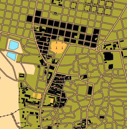
Meanwhile back at orienteering, another of the things I wrote about was OpenOrienteeringMap. This is still going strong as well, and has a solid user base in this country, and the unbelievable ability to generate an orienteering map of just about anywhere in the world. A small prize if anyone finds me and can say where the map extract is from. Anyway, Hertfordshire Orienteering Club now have a Tuesday night series of 45 minute score events throughout the summer, most of which use OOM. You can see examples on HH Routegadget site, like this race in St Albans, and this one in Hertford. Numbers at these Tuesday night events are gradually moving up, and what started with 10 as a good turnout now sees 20 or more most evenings. What's even more encouraging is that quite a lot of these are complete newcomers to the sport.

And that has conveniently dragged Routegadget into the conversation. Back in 2013 I was somehow talked into trying to implement a Javascript version of what was originally a Java application. (Nerd humour alert: Java is to Javascript as Ham is to Hamster. Or Car is to Carpet. Or various other versions I'm sure.) Routegadget needs a few pages of its own, so we'll leave it there for now.

But now we must return to where this blog started: the World Orienteering Championships. This year WOC is in Estonia.  I've never orienteered in Estonia. James fancied going somewhere to fill up the long summer holiday. And so we're off to Estonia on Friday to follow the GB team, and sample the delights of some maps that have quite a lot of brown (with some interesting contour detail) but possibly more green and blue than is ideal. Time to get back into spectator-geek mode. Watch this space.

Saturday, May 19, 2012

St Albans parkrun

Not the most technical course even by Verulamium standards
Parkrun keeps coming up when people discuss how orienteering should be attempting to present itself, and today I got a first chance to try it out. The St Albans version started in January this year in Verulamium, one of our regular Saturday Series areas. This was also a chance to work out how we might need to modify Saturday Series arrangements to avoid any clash.

The idea is very simple: a 5km run held every Saturday morning in the same place. Entry is free but you need to register on the website beforehand. This allows you to print off a bar code to take with you. Then all you need to do is turn up on the start line and join in. I set off with 120 other runners as the bells of St Michael's Church chimed 9.00 o'clock. A show of hands on the start line showed quite a high proportion of first timers like me (nearly a third looking at the results) but the course instructions were quite simple: follow the guy in white and do three laps of the lake.

The race itself was pretty much what I expected: a few fast guys at the front, a few walkers at the back and quite a cross-section of shapes, sizes and speeds in the middle. I set off too fast as normal, and got passed by people as the race went on, including two runners about half my height who turned out to both be 14. Three laps of the lake is just about manageable before terminal boredom sets in and then it's just a short sharp 5 metre climb to the final long flat finish straight. My target had been 22 minutes so 21:55 was perfectly acceptable even if my watch did only register 4.95km. Maybe next time I won't do 5 km beforehand running to the start from home. After crossing the finish line you are given a small plastic tag with a finish position and bar code on it: the modern equivalent of the good old raffle ticket which nearly made it in at number 2 on my list of orienteering things you didn't know you had missed. Results are done using a phone to read your registration bar code (carefully retrieved from a plastic bag in the pocket on my shorts) and your finish tag, and the correlated with finish times recorded on the finish line. Results were on the website that afternoon and I even got a text message telling me how I had done.

So why is this proving so successful and what can orienteering learn from it?

The format is simple, easy to understand and accessible. Everybody has a reasonable concept of what 5 kilometres on a surfaced path involves. It's far enough to be a worthwhile run for most, but short enough not to put people off. And you don't need to keep looking at the fixtures list to find when the and where the next event is.

The technology is used very effectively. The website is attractive and informative. Registration and timing bar codes are simple and work well.

Requirements for volunteer effort are relatively small. Eight people are acknowledged on the results page. I spotted one finish timer, two on results download, and three or four marshals on the course.  Doing away with registration by asking people to do it on the website is a key saving.

It's free. To be honest I'm sure people would be willing to pay one or two pounds if asked, but if the financial model doesn't need it then this can surely only help to increase attendance.

Much of this is of course is where Orienteering on demand is trying to go.

Monday, April 30, 2012

Orienteering On Demand

Orienteering on demand results screen

After a lot of discussion I have finally developed a prototype of a web front end for my Orienteering on Demand concept. Helen has been looking at various ways of making permanent courses more usable (and used) and this often came down to some sort of mobile phone app. Last year we put together an Android app that read QR codes, recorded split times and then uploaded them to the web. What was really needed was a better web end to display results.

I've now put together a first attempt at that website. This turned out to be quite a lot easier than expected once I had discovered yii. (If you wouldn't know a PHP framework from an overgrown  re-entrant then don't worry. If you would, then yii is highly recommended.)

It's very early stages at present, but it shows a lot of the ideas. The bit I'm particularly pleased with is the GPX file upload. This allows you to upload a GPX file from a phone or watch, and then works out how close you got to each of the controls on a course. True virtual orienteering in action. The current site includes a few example GPX files of me running around the local park.

I'm still not sure quite where this is going. Do I want to run a single website for the world to use (the Winsplits approach) or would it be easier to allow clubs to run their own sites (the Routegadget approach)? Do I make it open source and let people add their own enhancements? Do I publish an API to allow people to interface their own apps? We'll see what the response is.

There's a lot more to do, but as a start I reckon this is now worth letting into the wild.

Monday, April 16, 2012

Westfield Orienteering


How difficult can it be to navigate round a shopping centre? Harder than you might imagine when it is Westfield overlooking the Olympic Park at Stratford, with four main levels plus three separate car parks each with nine floors. You can see a map extract on the left, and the full map is here. At one point I had to check the lift buttons to confirm that it wasn't possible to get to the Second floor of the shopping centre from where I was at the time. I least I didn't end up taking the lift between controls as many people did even if it is apparently quicker to go both up and down nine levels in a lift than it is to run the stairs. And just to put you off there was a view of the Olympic Stadium around every corner. I can confirm that the roof of Car Park A (that's level P9 if you are paying attention) should provide a great view of the Olympic Opening Ceremony. I wonder if they are selling tickets?

Meanwhile back at the orienteering, the event was the inspiration of Josh Jenner, who had negotiated access early on a Sunday morning, before the shops opened. The next master stroke was to convince Ollie O'Brien (the City of London Race mapper) to produce the map. Nearly 100 people took part, split over five mass starts at 15 minute intervals from 09.00 to 10.00. The start was headlong down the steps towards Stratford International Station, although some did turn straight round and head back indoors to avoid the cold wind. Control 101 was 10 m from the start horizontally, and an equal distance vertically. After that there was a chance to start working out how to join up all 28 controls on the 60m sprint to 102. I think it is safe to say that nobody will have come up with the same route.

I set out with the intention of simply doing a level at a time and working from the bottom to the top. This turned out to be a rather naive plan as it became apparent that getting between levels was not trivial. Stairs and elevators were helpfully marked with brown and blue arrows (brown for down to the earth, blue for up to the sky), but they weren't always where you wanted, and some were blocked off by building work. Just working out where the various bits of map joined together proved quite a challenge, not helped when you found out that level P4 in Car Park C was above Level P5 in Car Park A for instance. Controls were distributed across three terrain types: indoor shopping centre, outdoor ground level (including a trip to Stratford Underground and Bus Station) and car park roof level. You can see a few more photos here.

My GPS watch ended up showing 5.12km in 30.53, although it clearly struggled quite a lot with the indoor bits, and my route choice was far from ideal. Most people seem to agree that getting them all involved something around 5km, which for an area little more than 500m by 400m (by about 30m) is quite impressive. The results show that 39 people managed to get all the controls in the 45 minute time limit, plus quite a few who thought they had only to find they had missed one or two (or three or four...). James, Peter and Helen went round together and managed to get them all in 37:29 although this was apparently helped by having two maps so they could take it in turns to plan ahead and navigate.

A great day out, and one which will hopefully be repeated (and extended) later.

Tuesday, June 29, 2010

OpenOrienteeringMap from Start to Finish

Fancy putting on an orienteering event anywhere in the world but don't have a map? Then you've never heard of OpenOrienteeringMap. This amazing concept allows you to generate an orienteering map of just about anywhere based on OpenStreetMap, which describes itself as "a free editable map of the whole world". What this means is that thousands of people have been out and mapped everything they can find to create an on-line map. This has the huge benefit that it is open data, licensed under a Creative Commons licence (CC-BY-SA). Subject to certain conditions it is therefore essentially free to use as source data for other maps.

Ollie O'Brien, the man behind YepSport and the mapper for the London City Race amongst other things, has developed OpenOrienteeringMap that now allows you to generate an orienteering map based on OSM. This has been used by SLOW for their monthly street-O events around London. Last night I put on a Street-O in St Albans as part of the HH Summer Series to find out what was involved in staging a race like this.

First step as ever was to select an area. The north-east corner of St Albans is an area known as Jersey Farm. This has some complex housing estates joined by a network of paths which seemed just about right for a Street-O. To make life easy I decided on a 45 minute score event. So let's see what an OOM map of Jersey Farm looks like.

1) Go to http://oobrien.com/oom/. The default view shows Docklands. You can enter a postcode to go directly to somewhere in the UK, or use the zoom facilities to move to wherever you want to use for your map.

2) The default values of the various options are OK to start with. You have a choice between "Street-O Map" or "Pseud-O Map". The Street-O map is black and white and only shows features such as roads, paths, railways, rivers and large buildings. The Pseud-O map attempts to reproduce a standard orienteering map using the ISOM map specification. To me this looks much nicer, but for a street event it really isn't needed, and it's simpler to stick with the black and white version.

3) Once you have moved to the area you need then you can generate the map. Click on the "Create a map" button. This brings up the Map Builder window. You can then select the paper size, map scale and map type. There is also a check box labelled "Include controls". If you leave this box checked then you can add start, finish and controls to the map when you generate it. For my event I wanted to use OCAD for the course planning so I cleared the check box.
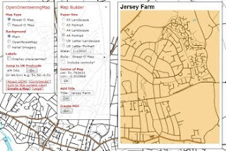
4) You then need to left click on the map to mark the centre of your map. This brings up a brown rectangle showing the exact size of your map. You can move this around as necessary by left clicking again, or by selecting a different scale, page size or orientation. For Jersey Farm I went for a 1:10,000 map. Once you have the correct area click OK, and then add a map title if needed, and click OK again.

5) You will now get the message "Creat PDF". Click the button labelled "Go!" and you will get your very own map in PDF format. This is named oom.pdf by default, so it is safest to rename it straight away and save it on your computer. You may well end up generating several versions of the map during the planning process so you need to make sure you are using the correct one.
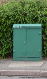
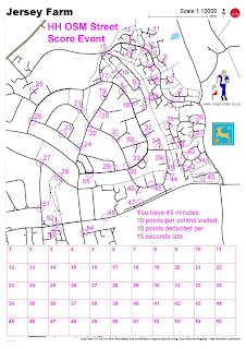
Now to plan the course. To make life easy you don't want to have to put out controls so you need to find some other way of proving people have visited the correct sites. SLOW use questions about something in the middle of the circle ("what is the name of the pub" and even "what sort of elephant is this" for example) . For me this is too complicated, since it makes life difficult for the planner to create the questions in the first place, and it is annoying as a competitor having to stop to write down long answers or hunt around for obscure answers. I therefore went for something simpler. Jersey Farm is covered in green telephone connection boxes, most of which have a nice painted number such as AL062 20. Getting runners to write down the last two digits seemed the best idea. A quick run around the area and I had found about 50 possible control sites. I still had a few parts of the map with no controls, but a quick hunt around on Google StreetView helped find a few more. It also raised hopes a few times when I spotted a fuzzy green shape in the distance only to find it was a green recycling bin. It turned out that runners at the event had exactly the same problem. The photos aren't quite good enough to read the labels so I had to do another run round to check them. In the end I went for 55 controls. This was probably a little over the top, but it does give runners something to think about.
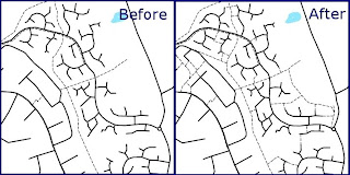
The event does of course rely on the quality of the OSM base map. In general it was pretty good, but whilst checking sites I did notice several things that needed changing or adding. The great thing about OSM is that you can always make the changes yourself. That isn't really what this is meant to be about, but for those who are interested I used JOSM to edit the map and add the odd extra road, several missing paths and some parks.

I wanted to use OCAD to generate the course. This won't accept PDF files as a background map so I first converted the PDF file to a JPG using GIMP. You can then use the standard OCAD course planning features. This allowed me to add the rules, a set of boxes for answers plus some extra logos. You can always use the built-in OOM function to add start, finish and controls if you don't have OCAD.
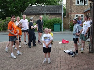
And so to the evening of the event. With no controls to put out it was simply a case of turning up at the start with a pen, clipboard and watch and setting people off. I put the start and finish at a green box so that people could see exactly what they were looking for before they started. Everybody got at least 19 controls, with the winner managing 42 in the 45 minutes available. You can see what routes some of the runners took on the HH RouteGadget site. The comments were all very positive, no doubt helped by the good weather and the interesting nature of the terrain. As ever there was much discussion about the map. The main issue was one I was already aware of from some of the SLOW events: open areas such as parks and fields do not show up. You can therefore end up staring at a large open space in front of you and wondering quite where you would come out if you ran across it, and whether you'll get stuck behind an uncrossable fence before you reach the road or path you want to be on. There's no easy answer to this, but it is generally fairly obvious once you get to the particular location. Using the full-colour Pseud-O map would help, and several people commented that they would prefer it.

Overall this event confirmed that it is perfectly possible to hold an event based on OOM. Jersey Farm itself turned out to be perfect, with surprisingly little traffic. Next time all I really need to do is move the start and finish and we could use pretty much the same set of controls. And then there's other bits of St Albans, and Mike said that Harpenden looks possible, and I've always wanted to do something in Hatfield, and then we could try Shenley or Welwyn or even bits of Watford. Looks like the Hertfordshire Street-O League may not be far away.

Sunday, September 13, 2009

Orienteering meets art in Trafalgar Square

On Friday September 11th 2009 Adrian had his hour of fame on top of the 1.7m (wide) x 4.4m (long) x 8m (high) fourth plinth in Trafalgar Square as part of Antony Gormley's One&Other project. This provides a chance for 2400 people (one an hour for 100 days) to occupy the fourth plinth and do whatever they want. Brooner came up with the great publicity angle that this could be the world's smallest orienteering event. Around 20 other orienteers and even a few members of the public took the chance to run in the first orienteering event to be held in Trafalgar Square.

The whole thing was broadcast live on the internet, as indeed all 2400 hours of the project will be. Looking at the coverage afterwards it may have been a bit difficult to work out what was happening at the time, and even if you were there it wasn't immediately obvious. Adrian was so far above us that it was quite hard to communicate, especially over the noise of the fountains. The theory was that he would run a course on the plinth and then someone would run the equivalent course in the square. It soon became obvious that this was a bit difficult to synchronise so it turned into more of a straight relay.

The extra complication was that each course would outline a letter and everything would be recorded on a GPS watch that was passed from runner to runner, and if we got everything right then we would spell out a message. Alan Leakey was given the job of official starter and a set of maps with courses labelled O, N, E, &, T, H, R, P, L, I and G. His job was then to hand these out in the right order to spell the message. Orienteers from London Orientering Klubb, South London Orienteers, Southdowns Orienteers, Hertfordshire Orienteering Club, Chigwell Orienteering Club, Havering and South Essex Orienteering Club, Saxons Orienteering Club, South Midlands Orienteering Club and possibly a couple of clubs I didn't spot took part. The South Midlands runner was Roger Williams, who had already had his own hour on the plinth a few days earlier.

Discussions with Adrian before the event had concluded we had a chance of managing "ONE & OTHER PLINTH O" in the one hour available, but the unofficial target was to try to manage "ONE & OTHER PLINTH ORIENTEERING". As we came towards the end of the hour we had got to the T in orienteering, but Alan was desperate to finish off. The bright yellow cherry picker drove up to get Adrian down and replace him with the next plinther, but we relocated the start and finish a few metres and continued around it. I spotted that we could stop at "ORIENTEER" and that would still make sense, and even provide a better reference to the person who had started all this off in the first place. And so at just past 14.00 I set off on the final R, telling each control holder as I passed that we had finished. In total we had run 24 courses covering 8.56 kilometres in 52:47.

After the event it was simply a matter of downloading the GPS track and extracting the message. The good news was that we had a full trace from the whole race. The bad news was that my vague idea of doing something in Routegadget to extract the letters didn't really work. After some experimentation the final method turned out to involve quite a complicated process as follows:

1) Read GPS trace from Garmin Forerunner 205 using SportTracks and create a GPX file for each letter.

2) Import each GPX file into QuickRoute and use this to create a JPG image showing the letter. QuickRoute had the nice extra that allows the colour at any point to indicate how fast you are running. Thus green sections show bits where people were moving fast, whilst red is slow.

3) Use IrfanView to do a batch conversion of the JPG files. This provided an easy way to crop and resize all 24 letters without doing it painfully one at a time.

4) Create a 9 by 3 Word table and import the JPG letters into this for final printing.

And so as a contribution to the art created in association with this project we come to the final result, as shown below.

The start and finish are at the bottom left of each letter, and this means courses have to be planned so they don't go through this point. That explains why the E is backwards, the T is on its side and the L is upside down.

A few related links:

Thursday, September 10, 2009

Tower, 52m, northern foot

Any suggestions where this might be? I guess it's not really that difficult to work out that it is Nelson's Column in Trafalgar Square. Tomorrow the general public will be getting the chance to orienteer around the square when Adrian Bailey spends an hour on the fourth plinth as part of the One & Other project. Helen and I have been helping to set things up so I am mapper and planner and Helen is organiser for what promises to be an interesting experience. We're still not quite sure exactly what will happen, but we have maps, control flags and SI kit so it should look like a proper race. Brooner has found an interesting publicity angle, claiming it to be the World's smallest orientering event.

You can get a sneak-preview of the map in Routegadget.

If you can't be there, don't miss the live web broadcast from 13.00 to 14.00 BST.

And that should provide a perfect warm-up for the 2009 London City Race on Saturday.

Thursday, October 16, 2008

City of London Orienteering Race

What an event. If you haven't seen it I recommend starting by looking at the map and courses in Routegadget and then seeing gg's video. Then there are the results plus lots of pictures, discussion and comments from officials on the official event web site.

The map, produced by Ollie O'Brien, is a pure work of art. There laid out in front of you is the whole City of London, from the remains of the Roman walls (in the olive green just north of control 135) to St Paul's Cathedral (control 151) to modern skyscrapers such as the Gherkin (control 137).

This was a chance to orienteer around the streets of London, which on its own would have made a great day out. The street network is not particularly complex, but it is good enough to make the navigation interesting, and around every corner you find a view of some well-known building to distract you. The start and finish were in Broadgate Arena next to Livepool Street Station (as shown in the photo of prizegiving on the left). The majority of the 400 competitors arrived by public transport and could sit in the warm sunshine while they waited to start or to discuss route choices after they had finished.

But the added element on top of all that was the final few controls spread around the Barbican Centre. The is spread over multiple levels, and proved a real challenge to map. Never before have so many people been so confused by so few controls.

It's also worth looking at Ollie's web site where he explains some of the technology behind the race.